

Queensland is on storm watch as Tropical Cyclone Jasper intensifies. Forecasters say Jasper could cross the coast north of Mackay.
Cyclone Jasper Threatens Region, Risk at Highest
Cyclone Jasper, a powerful weather system, is posing a significant threat to the region as it continues to gain strength. Upgraded to a category 3 cyclone, it is expected to intensify further, potentially reaching category 4 or even category 5.
While the forecast indicates a weakening trend over the weekend, Jasper is likely to remain a tropical cyclone for the next week, causing concern. Moving south-south-west into the Coral Sea, it is projected to turn towards the west this weekend.
The timing and severity of its potential impact on the coast remain uncertain, but the highest risk lies between Cooktown and Mackay. This occurrence is unusual as Jasper is the first cyclone of the season and the first to form off Australia in December during an El Niño.
Communities in the affected areas are urged to make necessary preparations, as the slow-moving nature of the cyclone allows for sufficient time to secure and safeguard their surroundings. Regular updates will be provided by the Bureau to keep communities informed and well-prepared.
Key Takeaways
- Cyclone Jasper has been upgraded to a category 3 system and is forecasted to strengthen further to a high-end category 4, with the possibility of reaching category 5.
- The cyclone is expected to weaken over the weekend but is likely to remain a tropical cyclone for the next week.
- Jasper has moved south-south-west into the Coral Sea and is expected to turn towards the west this weekend, with the highest risk of coastal impact between Cooktown and Mackay.
- This is the first tropical cyclone of the season and the first to form off Australia in December during an El Niño, making it a rare occurrence for this time of year.
Cyclone Jasper’s Strength and Forecast
Cyclone Jasper has been upgraded to a category 3 system, indicating its increasing strength and potential impact on the region. The cyclone is expected to further strengthen to a high-end category 4, with the possibility of reaching category five.
However, forecasters predict that it will weaken over the weekend. Despite the weakening, Cyclone Jasper is likely to remain a tropical cyclone for the next week. In terms of movement, the cyclone has moved south-south-west into the Coral Sea and is expected to turn towards the west this weekend.
The timing and severity of the coastal impact remain uncertain, but the highest risk lies between Cooktown and Mackay. The seven-day forecast shows potential impact from late Monday onwards.
Jasper’s Movement and Potential Impact
Moving south-south-west into the Coral Sea, Jasper’s trajectory and potential impact on the region will now be examined. The cyclone is expected to turn towards the west this weekend, although the timing and severity of its coastal impact remain uncertain. The highest risk lies between Cooktown and Mackay, with the seven-day forecast indicating a potential impact from late Monday onwards.
This movement is unusual as Jasper is the first tropical cyclone of the season and the first to form off Australia in December during an El Niño. It is rare to see a cyclone in December, making this occurrence unusual for early December. The Bureau of Meteorology will continue to issue regular updates as the situation evolves, urging communities to prepare and stay informed.
Model predictions are converging to forecast that Tropical Cyclone Jasper is likely to make landfall between Mackay and Cairns early next week. Presently, the most probable location for crossing appears to be between Townsville and Cairns.
According to predictive models, the system may either cross as a Category 1 or 2 cyclone, while some models suggest it could cross as a weaker low-pressure system. Residents of Mackay and Cairns are advised to start preparations in light of a potential coastal crossing. However, there is still some uncertainty regarding the exact strength and precise location of the crossing.
Unusual Occurrence of Cyclone Jasper
An unprecedented event, Cyclone Jasper’s occurrence in early December during an El Niño is highly unusual. Typically, cyclones forming off the coast of Australia in December are rare, but the fact that this cyclone has formed during an El Niño makes it even more unusual.
El Niño is a climate pattern characterized by warmer than average sea surface temperatures in the Pacific Ocean, which typically leads to suppressed cyclone activity in the Australian region. The formation of Cyclone Jasper challenges this pattern and raises questions about the impact of climate change on cyclone behavior.
As this unusual occurrence continues to unfold, the Bureau of Meteorology will provide regular updates to keep communities informed and prepared for any potential impacts.
Preparation and Response
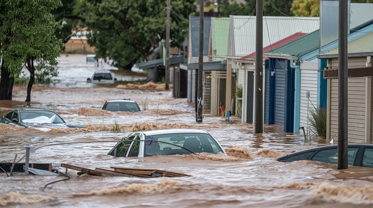
Communities in the region are urged to take necessary precautions and make preparations for the potential impact of Cyclone Jasper. As the cyclone continues to strengthen, it is essential for residents to batten down the hatches and secure their homes and belongings.
The slow-moving nature of Cyclone Jasper provides some time for communities to adequately prepare. The Bureau of Meteorology will keep communities informed with regular updates on the cyclone’s movement and potential impact. It is crucial for residents to stay informed and heed any warnings or advice issued by the authorities.
While the timing and severity of the coastal impact remain uncertain, the highest risk area is between Cooktown and Mackay. Given the potential impact, it is prudent for residents to make necessary preparations and stay vigilant.
Conclusion and Next Steps
Taking appropriate measures to ensure safety should be the priority as Cyclone Jasper continues to pose a significant threat to the region. With the cyclone upgraded to a category 3 system and the potential for further strengthening to a high-end category 4 or even category 5, it is crucial for communities to prepare and batten down the hatches.
Although the timing and severity of the coastal impact remain uncertain, the highest risk lies between Cooktown and Mackay. The slow movement of Cyclone Jasper provides some time for preparations, but it is essential to remain vigilant and stay informed with regular updates from the Bureau. http://www.bom.gov.au/cyclone/index.shtml
While Queensland’s cyclone season typically peaks in February and March, this rare occurrence of a December cyclone emphasizes the importance of being prepared for unexpected weather events.
Albion News is a great place to find informative, up-to-date news articles. We provide a wide range of unique articles that offer an interesting perspective on current events from around the world and from various different sources. You can easily search for the topics that matter most to you and explore in-depth pieces that provide insight into the issues and important debates occurring today. Albion News helps you stay informed with carefully researched and credible stories!