

South-east Queensland has been smashed by torrential rain, which has caused flash flooding on major roads and swamped cars and homes.
Tropical Cyclone Lincoln Forms as Queensland Soaked
The emergence of Tropical Cyclone Lincoln amidst Queensland’s saturated landscape has sparked concerns and vigilance among residents and authorities. As the cyclone gathers strength in the Gulf of Carpentaria, the impending threat of its landfall looms large over communities bordering the Northern Territory.
With the region already grappling with heavy rainfall and potential flooding, the prospect of intensified winds and further precipitation amplifies the urgency for preparedness and response measures.
The evolving situation necessitates a close watch on weather updates and community responses as Tropical Cyclone Lincoln continues its trajectory towards Queensland.
Key Takeaways
- Brisbane experienced its wettest day since 2022, with heavy rainfall attributed to easterly flow and an upper trough.
- Tropical Cyclone Lincoln formed in the Gulf of Carpentaria, posing potential impacts of wind and heavy rainfall.
- Weather alerts faced delays and criticism, impacting Brisbane and Gold Coast residents.
- Inland storms are forecasted, but the risk of intense rain in Brisbane and Gold Coast is easing.
Storms Soak Brisbane, Flash Floods Wreak Havoc
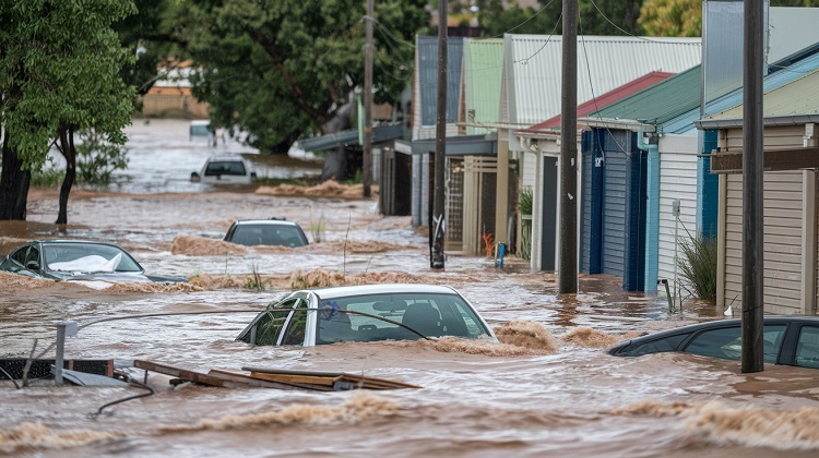
The recent deluge that inundated Brisbane with over 180mm of rainfall in a single day has left the city reeling from the impact of flash floods and subsequent chaos. As creeks overflowed and roads became impassable, the residents of Brisbane faced a situation that strained emergency services and highlighted the vulnerability of the community in the face of such extreme weather events. The aftermath of this storm has underscored the pressing need for effective disaster preparedness and response strategies in the region.
Extreme Rainfall in Brisbane
Amidst the recent storms in Brisbane, the city experienced unprecedented extreme rainfall, marking it as the wettest day since the 2022 floods. Over the last 24 hours, Brisbane received 183mm of rain, leading to overflowing creeks and widespread waterlogging. Particularly hard-hit areas included Logan, Brisbane, and Redland, with places like Rosalie recording 209mm of rain and Mount Coot-tha 195mm.
The heavy downpour resulted in low-level flooding in many homes, prompting Queensland Fire and Emergency Services to conduct seven swift water rescues. Despite the dangerous conditions, some residents found themselves navigating flooded roads. The Bureau of Meteorology issued a severe thunderstorm warning at 8.15 am, which was later lifted as heavy falls abated, affecting not only Brisbane but also the Sunshine Coast.
Flash Flooding and Road Closures
During the recent storms in Brisbane, the city grappled with severe flash flooding and subsequent road closures, causing widespread disruption and challenges for residents and local authorities. Creeks overflowed, leading to significant flash flooding in areas like Logan, Brisbane and Redland City.
The suburb of Rosalie received 209mm of rain, while Mount Coot-tha recorded 195mm. The flash flooding resulted in multiple road closures, limiting access to various parts of the city and complicating transportation. Despite the adverse conditions, some residents attempted to commute to work, navigating through flooded roads at their own risk.
The impact of the flash flooding on infrastructure and the community highlighted the need for improved emergency response measures and better flood alert systems.
Impact on Brisbane Residents
Residents in Brisbane faced significant challenges as they coped with the aftermath of the recent storms and flash floods that wreaked havoc in the city. Many residents experienced low-level flooding in their homes, with some waking up to find creeks in their backyards.
Queensland Fire and Emergency Services conducted seven swift water rescues, emphasizing the danger posed by the flooded conditions. Despite the dangerous circumstances, drivers were seen navigating flooded roads.
The failure of the Brisbane City Council’s flood alert system to warn residents added to the difficulties faced by the community. This event highlighted the vulnerability of residents to sudden and severe weather events, prompting a need for improved emergency response and communication strategies in the future.
Queensland Swift Water Rescues
Following the recent severe weather event in Brisbane, Queensland Fire and Emergency Services conducted multiple swift water rescues to assist individuals in dangerous floodwaters. The rescues were crucial as many residents faced perilous situations due to the overflowing creeks and flash flooding in the region.
Despite repeated warnings against driving into floodwaters, a significant number of rescues were necessary to save people who had ignored these precautions. The swift water rescue operations were carried out efficiently to ensure the safety of those in distress.
This highlights the importance of heeding official advice during extreme weather events to prevent endangering lives and requiring emergency interventions.
Bureau of Meteorology’s Warning
The Bureau of Meteorology issued a timely severe thunderstorm warning at 8.15 am, alerting residents to the impending weather risks. This warning provided crucial information to the public, highlighting the potential dangers associated with the severe weather conditions approaching Brisbane.
By issuing the alert, the Bureau aimed to ensure residents were prepared and could take necessary precautions to safeguard themselves and their properties. The detailed warning likely helped individuals make informed decisions regarding travel, outdoor activities, and other potentially risky ventures.
The Bureau’s proactive approach in disseminating this information underscored the importance of being vigilant during extreme weather events, ultimately contributing to public safety and awareness.
Infrastructure Challenges and Failures
Struggling to cope with the aftermath of the storm, infrastructure in Brisbane faced significant challenges and failures. Flash flooding caused road closures, limiting access to key areas and disrupting normal transportation routes.
The failure of the Brisbane City Council’s flood alert system left residents uninformed and unprepared for the rising waters. This lack of timely communication exacerbated the difficulties faced by both residents and emergency services.
Despite these shortcomings, some residents still attempted to commute to work, further complicating rescue and recovery efforts. The storm’s impact on infrastructure highlighted the need for improved warning systems and better preparedness for extreme weather events in the future.
Brisbane’s Creeks Burst Banks
Amidst the aftermath of the destructive storms that blew off roofs in Victoria, Brisbane experienced severe flash floods as creeks in the region burst their banks, causing widespread havoc and disruptions.
The city encountered its wettest day since the 2022 floods, with 183mm of rain falling within 24 hours. Areas such as Logan, Brisbane, and Redland were severely affected, with Rosalie receiving 209mm of rain and Mount Coot-tha recording 195mm.
Many residents faced low-level flooding in their homes, prompting Queensland Fire and Emergency Services to conduct seven swift water rescues. Despite the dangerous conditions, drivers navigated flooded roads, while the Brisbane City Council’s flood alert system failed to provide adequate warning.
The infrastructure impact led to road closures, restricting access to certain areas.
Regional Impacts and Weather Conditions
Highlighting the regional impacts and prevailing weather conditions, the recent storms in Brisbane have significantly disrupted daily life and infrastructure in various areas. With Brisbane experiencing its wettest day since the 2022 floods, the city received 183mm of rain in the last 24 hours, leading to creeks overflowing and causing flash flooding and road closures in Logan, Brisbane, and Redland areas.
Specific areas like Rosalie received 209mm of rain, while Mount Coot-tha got 195mm. Residents faced low-level flooding in their homes, necessitating seven swift water rescues by the Queensland Fire and Emergency Services. Despite challenges, some residents still commuted to work, but infrastructure was notably impacted, with roofs blown off houses in Victoria due to the volatile storms.
Background and Weather Impacts
Severe weather events in Queensland have recently led to critical impacts on communities and infrastructure, sparking concerns over the accuracy and timeliness of weather alerts. Brisbane City Councillor Fiona Cunningham apologized for delayed weather alerts caused by a technical error from Weatherzone, while Gold Coast mayor Tom Tate criticized the Bureau of Meteorology for underestimating rainfall.
Over 1,000 homes lost power on the northern Gold Coast, with investigations ongoing. Brisbane experienced its wettest day since 2022, although the rainfall was less compared to previous floods.
The heavy rainfall was attributed to the easterly flow and upper trough, exacerbating the situation. These events highlighted the importance of reliable and timely weather alerts for community safety and preparedness.
Tropical Cyclone Lincoln Formation
Recent weather events in Queensland have shifted focus to the formation and impacts of Tropical Cyclone Lincoln in the Gulf of Carpentaria. This cyclone has officially formed as a category one system and is projected to make landfall near the NT-Queensland border.
Gulf communities are on high alert due to already saturated conditions, with areas like Burketown and Doomadgee experiencing significant rainfall. The main concerns associated with Tropical Cyclone Lincoln are strong winds and the potential for heavy rainfall.
It is estimated that it may take up to two days for the water from catchments to flow into these gulf communities, increasing the risk of flooding and associated hazards.
Gulf Communities Alert
As Tropical Cyclone Lincoln continues to progress towards the NT-Queensland border, heightened alert levels are in place for Gulf communities due to the saturated conditions exacerbated by the significant rainfall in flood-affected areas like Burketown and Doomadgee.
The intense rainfall in these regions has left the ground already waterlogged, increasing the risk of flash flooding and riverine flooding as the cyclone approaches. Gulf communities are urged to stay vigilant and prepared for potential evacuation orders, as the combination of the saturated ground and the incoming cyclone poses a serious threat to the region.
Authorities are closely monitoring the situation and providing regular updates to ensure the safety of residents in these vulnerable areas.
Albion News is a great place to find informative, up-to-date news articles. We provide a wide range of unique articles that offer an interesting perspective on current events from around the world and from various different sources. You can easily search for the topics that matter most to you and explore in-depth pieces that provide insight into the issues and important debates occurring today. Albion News helps you stay informed with carefully researched and credible stories!