

The Bureau has issued severe weather warnings as more heavy rain is forecast to drench the Far North over the coming days.
Monsoon Trough Drenches Australia’s North, Heatwaves Loom
The recent monsoon trough off the coast of north Queensland has unleashed a deluge of heavy rainfall, posing a significant threat of flooding to the region. As the rain continues to pour, areas north of Cairns and the Daintree are particularly vulnerable to the relentless downpour.
However, the impact of this monsoon trough extends beyond the boundaries of Queensland, as Western Australia and South Australia grapple with the impending danger of scorching heatwaves.
These extreme weather conditions not only raise concerns for the welfare of animals and the presence of dead sea creatures on beaches but also pose significant challenges to ongoing recovery efforts in the wake of Cyclone Jasper.
With the monsoon conditions showing no signs of abating, the situation remains precarious, demanding our attention and continued exploration of the consequences of this weather phenomenon.
Key Takeaways
- Monsoon trough in Australia’s north is leading to heavy rainfall and possible flooding in Queensland, Northern Territory, and Western Australia.
- Areas north of Cairns and the Daintree region are particularly vulnerable to the impact of the monsoons.
- The monsoons are expected to last, with daily rainfall totals varying.
- In addition to the heavy rainfall, heatwave conditions are being experienced in Western Australia and South Australia, with temperatures soaring into the mid-forties.
Monsoon Trough and Heavy Rainfall
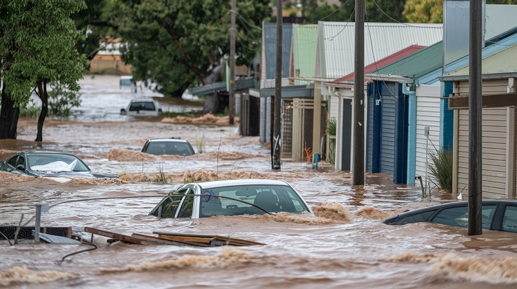
The Monsoon Trough has brought heavy rainfall to northern Australia, with some areas experiencing accumulated falls of up to 300mm since Thursday. This tropical low forming off the north Queensland coast has enhanced the monsoon trough, resulting in monsoon showers and storms expected for much of the week.
In some areas, falls of over 100mm in 24 hours are possible, leading to minor flooding across north tropical coast rivers. The renewed downpour is impacting regions that are still recovering from Cyclone Jasper, potentially setting back recovery efforts.
Queensland, Northern Territory, and Western Australia are expected to be hit with 100 to 300mm of rain, with areas north of Cairns and the Daintree area particularly vulnerable. The monsoons are expected to last, with daily totals varying.
Impact on South-East Queensland
South-East Queensland will experience a wet start to the week, with showers beginning on Monday. The monsoon trough that has been drenching Australia’s north is expected to bring unsettled weather to the region, with showers and thunderstorm activity throughout the week.
However, the showers are expected to die off towards the middle of the week. There is also the possibility of another system from the west bringing more showers and thunderstorms. Sizable rainfall totals of 50-100mm are possible in northern New South Wales and parts of south Queensland.
Flash flooding potential in Far North Queensland is a concern, as significant river, creek, and stream rises are expected. Major flooding events are also possible in the Flood Watch area.
Flash Flooding and Flooding Warnings
Flash flooding potential in Far North Queensland is a concern due to the significant rise expected in rivers, creeks, and streams. With the monsoon trough intensifying and a tropical low forming off the north Queensland coast, there have been accumulated falls of up to 300mm in some areas since Thursday.
Monsoon showers and storms are expected to continue throughout the week, with the possibility of falls over 100mm in 24 hours in certain regions. As a result, minor flooding across north tropical coast rivers is anticipated.
In addition, there is a flood watch in place in the Northern Territory’s north Western region, where major flooding events are also possible. These conditions could potentially impact roads and highways, leading to isolated communities.
Heatwaves in Western Australia and South Australia
As the monsoon trough continues to drench Australia’s north, another weather concern arises in the form of heatwaves in Western Australia and South Australia. Western Australia is experiencing severe heatwave conditions, with maximum temperatures soaring into the mid-forties. The Perth metro area and other key areas have been issued severe heatwave warnings.
Similarly, the North West Pastoral District in South Australia is also under a severe heatwave warning, with temperatures expected to reach the forties across APY Lands and Oak Valley. These hot conditions are forecasted to persist until Monday.
The high temperatures pose risks to both humans and animals, with concerns raised about the welfare of horses and the potential harm to animals during outdoor events. Additionally, recent rainfall is believed to have caused the death of sea creatures on the beach.
Risks to Animals
The extreme heatwave conditions and recent rainfall in Australia pose significant risks to the welfare of animals. Concerns have been raised about the welfare of horses in extreme heat, as they face potential harm during outdoor events. Horses are particularly vulnerable to heat stress, which can lead to dehydration, heat exhaustion, and even death.
Additionally, the recent rainfall has been linked to the discovery of dead sea creatures on beaches. The cause of their deaths is believed to be the sudden change in temperature and water conditions. This highlights the impact that climate events can have on marine life.
It is crucial for authorities and individuals to take necessary precautions to protect animals during such extreme weather conditions.
Recovery Efforts and Setbacks
Efforts to recover and rebuild in the regions affected by the recent monsoon trough are facing potential setbacks due to the excessive rainfall. The heavy downpour has caused minor flooding across the north tropical coast rivers, further exacerbating the challenges faced by communities still recovering from Cyclone Jasper.
The excess rain could hinder the progress made in rebuilding infrastructure and restoring normalcy in the affected areas. With Queensland, Northern Territory, and Western Australia expected to receive 100 to 300mm of rain, the regions north of Cairns and the Daintree area are particularly vulnerable.
The monsoons are predicted to persist, with varying daily totals. It is crucial for recovery efforts to adapt to the changing conditions and ensure that the setbacks caused by the excessive rainfall are minimized.
Long-lasting Monsoon Conditions
The persistence of the monsoon conditions is becoming increasingly worrisome for recovery efforts in the regions affected by the recent rainfall. The monsoon trough, which has led to heavy rainfall and flooding in parts of Queensland, Northern Territory, and Western Australia, is expected to last for an extended period. This poses a significant challenge for communities already grappling with the aftermath of Cyclone Jasper.
The excess rain could set back recovery efforts and hinder the restoration of essential services and infrastructure. Additionally, the continuous downpour increases the risk of flash flooding and river rises, potentially isolating communities and impacting road networks.
The long-lasting monsoon conditions also raise concerns for animal welfare, particularly for horses exposed to extreme heat and sea creatures found dead on beaches due to recent rainfall.
Albion News is a great place to find informative, up-to-date news articles. We provide a wide range of unique articles that offer an interesting perspective on current events from around the world and from various different sources. You can easily search for the topics that matter most to you and explore in-depth pieces that provide insight into the issues and important debates occurring today. Albion News helps you stay informed with carefully researched and credible stories!