

Residents in Far-North Queensland are once again in the firing line of a Tropical Cyclone, which is currently intensifying off the coast.
Destructive Cyclone Kirrily Threatens North Queensland
As North Queensland braces for the impact of Cyclone Kirrily, the looming threat of destruction and devastation looms heavy in the air. With the Bureau of Meteorology issuing a tropical cyclone watch and predicting that Kirrily will make landfall near Townsville as a category three storm, the gravity of the situation cannot be ignored.
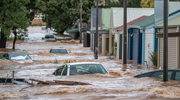
The potential for heavy rain, flooding, destructive winds, and a dangerous storm tide has prompted urgent warnings and calls for preparedness. As the region anxiously awaits the arrival of this fierce weather system, the question on everyone’s mind is: will North Queensland be able to weather the storm?
Key Takeaways
- Cyclone Kirrily is a severe tropical cyclone forming off the coast of Queensland.
- It is predicted to make landfall near Townsville as a category three storm, bringing heavy rain, flooding, destructive winds, and a dangerous storm tide.
- Residents in the affected areas are urged to prepare long-life food and water supplies, fill up vehicles with petrol, and have a power pack at home.
- The system is currently located over the central Coral Sea, approximately 860 km east-northeast of Townsville.
Formation and Intensification of Cyclone Kirrily
Cyclone Kirrily, a severe tropical cyclone, is currently intensifying off the coast of North Queensland, posing a significant threat to the region. The Bureau of Meteorology predicts that Kirrily will make landfall near Townsville as a category three storm. With this system comes the risk of heavy rain, flooding, destructive winds, and a dangerous storm tide.
A tropical cyclone watch has been issued from Ayr to St Lawrence, including Mackay and the Whitsunday Islands. If Kirrily does make landfall as a category three tropical cyclone, wind gusts of 165 to 224 km/h could be possible.
Residents from Innisfail to Airlie Beach are urged to prepare long-life food and water supplies, fill up vehicles with petrol, and have a power pack at home. It is important for Queenslanders to stay up to date with forecasts and warnings, as emergency services may take up to 72 hours to reach devastated towns.
Predicted Landfall Location and Category of Cyclone
As Kirrily continues to intensify off the coast of North Queensland, meteorologists are closely monitoring its projected landfall location and category. The Bureau of Meteorology predicts that the cyclone will make landfall near Townsville as a category three storm. This means that if the system hits land at this intensity, it could bring wind gusts of 165 to 224 km/h. As a result, there is a risk of heavy rain, flooding, destructive winds, and a dangerous storm tide.
A tropical cyclone watch has been issued from Ayr to St Lawrence, including Mackay and the Whitsunday Islands. Residents in the path of the cyclone are advised to prepare long-life food and water supplies, fill up their vehicles with petrol, and have a power pack at home. It is crucial for Queenslanders to stay up to date with forecasts and warnings to ensure their safety.
Potential Destructive Impacts of Cyclone Kirrily
The potential destructive impacts of Cyclone Kirrily include heavy rain, flooding, destructive winds, and a dangerous storm tide. As the cyclone intensifies off the coast of North Queensland, it poses a significant threat to the region.
Heavy rain is predicted to hit the central, south, and southeast parts of the state, leading to possible flooding. Destructive winds, with gusts of up to 224 km/h, could cause extensive damage to infrastructure and property. Additionally, a dangerous storm tide is expected, which could result in coastal inundation and erosion.
These impacts highlight the importance of preparedness and safety measures for residents in the affected areas, such as stocking up on long-life food and water supplies, filling up vehicles with petrol, and staying updated with forecasts and warnings.
Preparations and Safety Measures for Residents
Residents in the affected areas must take necessary precautions and safety measures to ensure their well-being and minimize the potential risks posed by Cyclone Kirrily. The Bureau of Meteorology has advised residents from Innisfail to Airlie Beach to prepare long-life food and water supplies. It is also recommended to fill up vehicles with petrol and have a power pack at home.
Emergency services may take up to 72 hours to reach devastated towns, so it is crucial for residents to be self-sufficient during this period. Queenslanders are urged to stay up to date with forecasts and warnings to make informed decisions.
Additionally, disaster teams have reassured residents that the state’s power supply is prepared for the incoming disaster. By taking these precautions and staying informed, residents can better protect themselves and their property during Cyclone Kirrily.
Importance of Staying Updated With Forecasts and Warnings
Staying informed about the latest forecasts and warnings is crucial during Cyclone Kirrily in order to ensure the safety and preparedness of the affected communities. The Bureau of Meteorology has issued a tropical cyclone watch for a wide area along the Queensland coast, from Ayr to St Lawrence, including Mackay and the Whitsunday Islands. This means that residents in these areas should be prepared for the potential impacts of the cyclone.
By staying updated with the forecasts and warnings provided by the Bureau of Meteorology and other relevant authorities, residents can make informed decisions regarding their safety and take necessary precautions. It is important to closely monitor the cyclone’s track, intensity, and potential impacts, as these factors can change rapidly.
Regularly checking updates and following the instructions of local authorities can help minimize the risks associated with Cyclone Kirrily.
Expected Heavy Rain and Blustery Winds in Central, South, and Southeast Queensland
What are the potential impacts of Cyclone Kirrily in terms of heavy rain and blustery winds in central, south, and southeast Queensland?
As Cyclone Kirrily intensifies off the coast of North Queensland, it poses a significant threat of heavy rain and blustery winds to the central, south, and southeast regions of Queensland. The system, currently located over the central Coral Sea, is predicted to bring heavy rainfall and strong winds to these areas.
Weatherzone forecasts suggest that the impacts could be felt across these regions as the cyclone makes landfall near Townsville. The potential for flooding, destructive winds, and a dangerous storm tide is a primary concern as the system moves closer to the coastline.
Residents are urged to stay updated with forecasts and warnings and take necessary safety precautions to minimize the potential risks associated with this severe weather event.
Geographical Areas Affected by Cyclone Kirrily
As Cyclone Kirrily intensifies off the coast of North Queensland, its potential impacts extend beyond heavy rain and blustery winds, encompassing various geographical areas. The tropical cyclone watch is currently in effect from Ayr to St Lawrence, including Mackay and the Whitsunday Islands.
Residents in the region from Innisfail to Airlie Beach are being urged to take precautionary measures and prepare for the cyclone’s arrival. The system’s landfall is expected near Townsville, posing a significant threat to the coastal areas.
Additionally, the central, south, and southeast parts of Queensland are predicted to experience heavy rain and blustery winds as the cyclone approaches. It is crucial for residents in these areas to stay updated with the latest forecasts and warnings to ensure their safety.
Current Location and Track of the Cyclone
The current location and track of Cyclone Kirrily off the coast of North Queensland is of utmost concern as it continues to intensify and pose a significant threat to the coastal areas.
At present, the cyclone is located over the central Coral Sea, approximately 860 km east-northeast of Townsville. It is important to note that the cyclone’s track is subject to change, making it crucial for residents and authorities to stay updated with the latest forecasts and warnings issued by the Bureau of Meteorology.
The cyclone is predicted to make landfall near Townsville as a category three storm, bringing with it heavy rain, destructive winds, and a dangerous storm tide. The affected geographical areas include Ayr, St Lawrence, Mackay, and the Whitsunday Islands.
As the cyclone continues to progress, it is vital for individuals to take necessary precautions and adhere to safety measures to mitigate potential risks and ensure their well-being.
Assurance of Power Supply Preparedness
Given the potential impacts of Cyclone Kirrily on the coastal areas of North Queensland, ensuring the preparedness of the power supply has become a critical concern. The destructive winds and heavy rain associated with the cyclone pose a significant threat to the electricity infrastructure, which could result in widespread power outages.
To address this concern, disaster teams and power companies have taken proactive measures to ensure the power supply is prepared for the incoming disaster. These measures include conducting inspections and maintenance of power lines and equipment, reinforcing vulnerable infrastructure, and implementing contingency plans to quickly restore power in affected areas.
Impacts and Timeline of the Incoming Disaster
Impacts of the incoming disaster caused by Cyclone Kirrily on North Queensland’s coastal areas are expected to be severe and far-reaching. The cyclone, predicted to make landfall near Townsville as a category three storm, brings the risk of heavy rain, flooding, destructive winds, and a dangerous storm tide.
Wind gusts of 165 to 224 km/h could be possible if the system reaches category three intensity. The central, south, and southeast parts of Queensland are likely to experience heavy rain and blustery winds. The system is currently located over the central Coral Sea, approximately 860 km east-northeast of Townsville.
Residents from Innisfail to Airlie Beach are urged to take safety measures and prepare for the potential impacts. It is crucial for residents to stay updated with forecasts and warnings to ensure their safety.
Albion News is a great place to find informative, up-to-date news articles. We provide a wide range of unique articles that offer an interesting perspective on current events from around the world and from various different sources. You can easily search for the topics that matter most to you and explore in-depth pieces that provide insight into the issues and important debates occurring today. Albion News helps you stay informed with carefully researched and credible stories!