

Thousands of people are right now on alert with a tropical cyclone warning issued for Queensland’s far north, the state’s third this summer alone.
Cyclone Alert in Far North Queensland Escalates
The escalation of the cyclone alert in Far North Queensland has prompted a closer look at the potential impacts of Tropical Low 07U. With the likelihood of cyclone formation looming, the region faces a critical period of monitoring and preparedness.
As the situation unfolds, the focus shifts to the expected path of the weather system and the anticipated effects on vulnerable coastal areas. Stay tuned for further updates on the evolving cyclonic threat and the measures being taken to mitigate its consequences.
Key Takeaways
- Monitoring for cyclone development intensifies with risk level increasing to moderate.
- Potential cyclone named Lincoln poses escalating threats to coastal areas.
- Residents urged to stay informed, prepare, and heed warnings for safety.
- Severe weather warnings and flood alerts highlight critical need for vigilance and precautions.
Alert Issued for Southern Gulf Coast
An alert has been issued for the Southern Gulf Coast, specifically for the area west of Burketown in Far North Queensland, due to the potential development of Tropical Low 07U into a cyclone. The alert encompasses a watch zone from Port Roper to Burketown, where strong winds reaching up to 100 km/h and heavy rainfall are expected. There is a 40% chance that the tropical low will intensify into a cyclone, bringing with it the possibility of minor flooding in low-lying coastal regions.
Additionally, higher tides are anticipated between King Ash Bay and Port Roper as the monsoon trough in the region deepens. Residents in the alert area are advised to stay informed about the evolving weather conditions and to take necessary precautions.
Potential Cyclone Development on Friday
Forecasters are closely monitoring the anticipated development of a potential cyclone on Friday, with conditions conducive for significant intensification. The risk of developments is expected to increase from low to moderate, with favorable conditions for the system’s formation.
If the cyclone materializes, it is likely to be named Lincoln. The peak day for cyclone development is forecasted to be on Friday, raising concerns for the Far North Queensland region. Residents and authorities are urged to stay updated on weather warnings and prepare for possible severe weather impacts. As the situation evolves, ongoing monitoring and detailed forecasts will be vital in assessing the potential risks associated with the cyclone’s development.
Impacts of Tropical Low 07U
The potential impacts of Tropical Low 07U are being closely monitored as the system continues to show signs of intensification. Damaging wind gusts of up to 100km/h are expected, posing a risk to structures and vegetation in the affected areas.
There is also a potential for minor flooding in low-lying coastal regions due to locally intense rainfall along the southern Gulf coast. Higher tides are anticipated between King Ash Bay and Port Roper, increasing the risk of coastal inundation.
Additionally, the deepening monsoon trough in the region may exacerbate these impacts. Residents and authorities are advised to stay informed about the evolving situation and take necessary precautions to ensure safety and minimize potential damage.
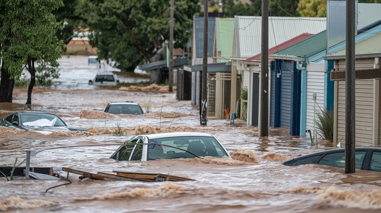
Flood Watch and Warnings Active
Monitoring of flood watch and warnings continues in Queensland’s far north as the region remains on alert for potential inundation risks due to the ongoing weather conditions. Active flood watch is in place for southern Gulf catchments, with major flood warnings issued for Eyre Creek and Flinders River. Additionally, moderate flood warnings are in effect for Diamantina and Nicholson Rivers. The catchments are already saturated from recent rainfall, necessitating ongoing monitoring of flood-prone areas.
With the potential for daily rainfall totals between 100mm to 150mm, the situation is being closely monitored for any developments that could exacerbate the flooding risk. Residents in the affected areas are advised to stay informed and prepared for possible evacuation orders.
Severe Weather Warnings Expected
An imminent escalation of severe weather warnings is anticipated in Queensland’s far north due to the prevailing weather conditions. The potential for severe weather alerts is set to increase starting Thursday, with Friday expected to be the peak day for cyclone development. The risk level for cyclone formation is projected to rise from low to moderate, with favorable conditions favoring the system’s development.
This impending weather event may lead to the naming of a cyclone, potentially named Lincoln, if it materializes. Residents in the region are advised to stay informed about the evolving situation and heed any official warnings issued by relevant authorities to ensure their safety and preparedness for the anticipated severe weather conditions.
Favorable Conditions for Cyclone Formation
In light of the imminent escalation of severe weather warnings expected in Queensland’s far north, the current focus shifts to the favorable atmospheric conditions conducive to cyclone formation in the region.
The presence of warm ocean waters, typically above 26.5 degrees Celsius, provides the necessary heat energy for cyclone development. Additionally, low vertical wind shear is crucial as it allows the storm’s structure to remain intact and organized.
A moist atmosphere, often associated with the monsoon season, aids in sustaining the cyclone’s strength by providing ample moisture for cloud development and precipitation. These favorable conditions increase the likelihood of Tropical Low 07U evolving into a cyclone, highlighting the need for continued monitoring and preparedness in potentially affected areas.
Forecasted Path for Tropical Low 07U
The projected path of Tropical Low 07U in Queensland’s far north indicates a westward movement, with potential impact expected along the Western Peninsula coast. This trajectory aligns with the majority of modeling forecasts, suggesting a shift towards the Western Peninsula.
As the system progresses in a westward direction, communities along the Western Peninsula coast should remain vigilant and prepare for potential effects of the tropical low. The movement of Tropical Low 07U raises concerns for coastal regions in its path, emphasizing the need for ongoing monitoring and preparedness measures.
Residents in these areas should stay informed about updates from the relevant authorities and take necessary precautions to ensure their safety during this time of heightened alertness.
Ongoing Monitoring of Flood-Prone Areas
Continuous surveillance of flood-prone regions is imperative during this period of heightened tropical weather alertness in Queensland’s far north. With active flood watches and warnings in place for southern Gulf catchments, including major flood alerts for Eyre Creek and Flinders River, and moderate warnings for Diamantina and Nicholson Rivers, the risk of flooding remains high.
The catchments are already saturated from recent rainfall, necessitating ongoing monitoring to track water levels and potential inundation risks. As the monsoon continues to bring heavy rainfall across the region, daily totals between 100mm to 150mm are expected, further increasing the likelihood of flooding in low-lying coastal areas.
Residents and authorities must remain vigilant and prepared for potential flooding events in the coming days.
Albion News is a great place to find informative, up-to-date news articles. We provide a wide range of unique articles that offer an interesting perspective on current events from around the world and from various different sources. You can easily search for the topics that matter most to you and explore in-depth pieces that provide insight into the issues and important debates occurring today. Albion News helps you stay informed with carefully researched and credible stories!